
Transportation Planning
Physical Address: 208 Capitol Hill, Nixon, Nevada 89424
Mailing Address: P.O. Box 256, Nixon, Nevada 89424
Phone: (775) 574-1000
Office Hours: Monday – Friday | 8:00am – 4:30pm
The Pyramid Lake Paiute Tribe established the Transportation Planning Department in 2009 with a 638 grant. The goal of the development of this department was to give the Tribe a more direct approach to evaluating and solving our transportation needs. As the program progressed the Tribe became comfortable with the fact that they had the skills and knowledge to implement the Tribal transportation funds. In 2012 The Tribe decided that they were ready to take on the responsibilities of a Program Agreement Tribe. The Transportation Planning program had entered into a program agreement in partnership with The Bureau of Indian Affairs Transportation Department allowing the Tribe to administer its own funds and work directly with Federal Highways Administration regarding programming issues. This has proven to give the tribe more leverage to govern the activities on tribal lands when it comes to planning, constructing and implementing the use of new roadways and pedestrian/bicyclist improvements.
See below for a more comprehensive explanation of what a Tribal Transportation Program Agreement is and what its purpose was when created.
Tribal Transportation Program Agreement
Prior to SAFETEA-LU, Indian Tribal governments worked directly with the BIA or the DOI, Assistant Secretary of Indian Affairs in implementing the Tribal Transportation Program (TTP) program.
Since SAFETEA-LU, Indian Tribal governments have a choice in administration of the TTP program. As a result, under 23 U.S.C. § 202(a)(2), the Secretary of Transportation is authorized to enter into a Tribal Transportation Program Agreement (TTPA) with an Indian Tribal government to carry out a transportation program and projects. This allows Tribes the option of working directly with the FHWA in the administration of their Tribal Transportation Program.
A Tribe with a TTPA administers its own TTP, as authorized by Chapter 2 of Title 23.
The purpose of a TTPA is to:
- Transfer to the Tribe all the functions and duties that the Secretary of the Interior would have performed with respect to a program or project under Chapter 2 of Title 23, other than those that cannot be legally transferred.
- To provide the Tribe or its designee, under a Referenced Funding Agreement (RFA), its share of TTP funds.
Tribal Transportation Improvement Program (TTIP)
FHWA Agreement Tribes Planning Process
The Federal Highway Administration Tribal Transportation Program team works in consultation with Tribal Governments to achieve transportation planning on Tribal lands. A Tribal Transportation Program (TTP) Agreement between the U.S. Department of Transportation and a Tribe provides an understanding that Tribal Governments inherit “all the functions and duties that the Secretary of Interior would have performed (Chapter 2 of Title 23, USC).” As per this legislation, a major planning effort FHWA has approval authority on, in partnership with a Tribe, is the development of an annual TTP Transportation Improvement Program (TTPTIP) derived from a list of eligible projects approved under a Tribe’s individual TIP. The transportation planning process on Tribal lands as a whole is carried out by the Tribal Government’s staff.
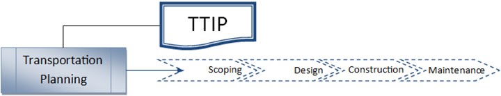
The Tribe updates its TTIP as projects become identified and or completed. Along with this update the Long-Range Transportation Plan (Long Range Transportation Plan) is also updated to reflect the changes in the list of roads and their disposition. It also identifies new roads which may be in the scoping phase to add to the TTIP and LRTP
What is a Long-Range Transportation Plan and what is it used for?
As defined in 25 CFR Part 170.400 and 410, the purpose of transportation planning is to “clearly demonstrate a Tribe’s transportation needs and to fulfill tribal goals by developing strategies to meet transportation needs. These strategies address current and future land use, economic development, traffic demand, public safety, health, and social needs.” The long-range transportation plan development process allows for the inventory and analysis of infrastructure often in collaboration with State, Regional Planning Organizations, Cities, Counties, and other stakeholders to identify projects to improve multi-modal transportation options locally and regionally. As such, and as referenced in 170.414, developing a long-range transportation plan (LRTP) is crucial in the formulation of a comprehensive tribal priority list or Tribal Transportation Improvement Program (TTIP) as a planning tool to program and deliver projects to meet the identified needs and for inclusion in the State Transportation Improvement Program (STIP).
See attached link to the Pyramid Lake Paiute Tribes LRTP document: Long Range Transportation Plan Narrative 2021
LRTP Appendix A Information Sources
Projects through our office can take years to complete due to funding restraints. The Transportation Planning Team consisting members representing planning, safety and management continue to work on all road priorities on the LRTP priority list as funding comes available. When funding comes available and the project has moved through all the phases listed above the Transportation Planning department hands the project over to the Tribe who maintains the roads, paths etc. through its Tribal Roads Maintenance Department.
Transportation Safety Program
The Pyramid Lake Paiute Tribe Transportation Safety Plan is a document based on the findings of the Tribes Transportation Planning office staff to be challenges for Tribal Transportation Safety in our Tribal communities.
Our plan is listed in the resources tree found on the left-hand side of the webpage. Please feel free to take a look at it and give us suggestions on how it can be improved on and what we may need to add as we look to update it in the coming year.
You can see the safety plan here: FINAL Strategic Transportation Safety Plan (STSP) 2015
Transportation Safety Plans
Transportation safety plans are a tool used by Tribes to identify and plan to address transportation risk factors that have a potential of leading to serious injury or death. Safety Plans also organize the efforts of a variety of entities to more effectively reduce risk. Safety plans can cover multiple transportation modes (roads, maritime, trails, air travel, and others). Safety plans may lead to implementation of a project or program, renewed efforts in an existing program, or further study of a roadway section (using an engineering study or Road Safety Audit).
ROAD SAFETY ASSESSMENTS OR AUDITS
What is a road safety assessment or audit?
A road safety audit (RSA) is defined as “the formal safety performance examination of an existing or future road or intersection by an independent, multidisciplinary team. It qualitatively estimates and reports on potential road safety issues and identifies opportunities for improvements in safety for all road users.”
The Transportation Safety Coordinator along with a team of experts and users conducted Road Safety Audits for SR445, SR446, and SR447 as well as all of the Tribal roads on the reservation. An engineering team hired and paid for by the Nevada Department of Transportation Safety evaluated the information gathered from the physical, in person audit and created a document pointing out areas that can be improved upon in the future. These documents have proven valuable in writing grant for additional dollars to do maintenance projects and add safety components to our roadways.
This is just another tool in ensuring that we have the most comprehensive information to make priority decisions on our roadway maintenance and planning efforts.
PROJECTS IN THE WORKS
The Transportation Planning Office works with the BIA/Federal Highways to administer the funds that we are contracted to receive each year by adding or continuing planning and saving towards projects listed on our Tribal Transportation Improvements Projects (TTIP). Projects are approved for placement on the TTIP through a resolution of the Pyramid Lake Paiute Tribal Council on a yearly basis.
Funds are distributed over a period of years to each project and as we build a nest egg for each we put them into motion with planning, engineering and construction being the major phases to address over a period of time or as the money comes available.
Currently, the list includes the following:
PROJECT | CURRENT PHASE OF DEVELOPMENT |
Wadsworth Bypass Road | 100% design phase completed. Construct will begin when funds (approximately 8.9million) become available through grants or endowments. |
Tahoe Pyramid Bikeway | 15% design phase to date. Construction projected to begin in 2026 if funds come available. |
Wadsworth New Community Building Parking Lot Expansion | 100% design phase completed in 2020. Funds are available to begin construction in 2021 when all utilities plans are completed. |
PLPT Administration Building Parking Lot | Design phase 90% completed. Projected to start construction in 2023 if funding become available. |
Transit Facility Parking Lot | 100% design phase completed. Review of plans and pre-construction activities. |
Wadsworth Complete Streets/Multi Use Walking Path near 447 in front of Natchez School | 100% design phase completed. Waiting for Right of Way document to begin construction. Construction should begin in 2021. |
COMPLETED PROJECTS
Availability of funding is key to getting projects completed. It takes time and continued work to get projects to completion.
The following is a list of projects that have been completed over the last 5 years:
Year completed | Project Name | Funding |
2015 | Wadsworth Community Center Parking Lot. | TTIP funds |
2016 | Pelican Point Project | TIGER Grant-Federal Funding/Transportation Match funds |
2020 | COVID 19 Road Closure of 445-446 | Emergency closure due to the spread of the virus. CARES act funding paid for this project. |
The Long-Range Transportation Plan and TTIP are currently in progress of being updated and revised to reflect changes that have occurred in the last 5 years. Several existing roads not currently on the TTIP are being proposed to be added so TTIP funding can start to be set aside to repair or upgrade these roadways.
Some additions may include:
- Sutcliffe Community Building Parking Lot
- S-S road
- Lakeview Drive Sutcliffe
- Pyramid Lake Road (Surprise Valley Road North of Warrior)
Any road not on the TTIP can not be maintained or built using Transportation Planning funds or Tribal Roads Maintenance Funds. It is vital to have these roads listed unless the Tribe has a specific reason to take on the burden of maintenance through tribal funds. All roads on the TTIP are considered “Public Access Roads” so anyone can use them at no cost.
OTHER PROGRAM COSTS
Funds are set a side each year for staffing and other administrative cost to run the program. Also included is the matching funds for the transit grant to ensure that they can be competitive in the grant process. This investment has turned out to be a win/win for the community as transit services are a necessary part of any community, large and small, to serve the needs of those who cannot afford a vehicle or chose not to use private transportation.
Please feel free to call our main line (775) 574-1000 ext. 1106, Johnnie Garcia, or 1107 Sherry Ely Mendes if you have any questions or would like to know more about the Transportation Planning Department.
RESOURCES
https://www.bia.gov/bia/ois/division-transportation – right click to open link to BIA transportation program information
https://highways.dot.gov/federal-lands/programs-tribal/safety/transportation-safety-plans- right click to open link to Federal Highways Administration web page.
https://www.safekids.org/car-seat?page=2 right click to open link regarding child passenger safety and safety for children in general.
https://ucsg.safekids.org/ right click to open link to find out what car seat is appropriate for your child’s needs.
https://www.cdc.gov/transportationsafety/pdf/native/TMVIP_Best-Practices_Guide_2016-a.pdf – right click to open page regarding transportation safety in Indian Country best practices.
Transportation Updates
November 20, 2025
Please send your comments/questions or concerns to the Pyramid Lake Tribal Transportation Department regarding the Lumos’ Tribal Admin Parking Lot Map/Plan. The deadline to submit comments is December 12, 2025. The map can also be viewed in the Tribal Admin Lobby.
Johnnie Garcia – jgarcia@plpt.nsn.us
Da Nelle Smith – dmith@plpt.nsn.us
See PDF of Tribal Administration Parking lot here: Admin Parking Lot Plan
March 27, 2025
The Wadsworth Bypass was designed to keep heavy traffic away from the school zone for safety concerns. Completed, it will be 2.9 miles paved from SR 427 to the SR 447 Olinghouse intersection. A & K Earthmovers is the awarded Contactor. Construction began November 18, 2024, and is projected to be finished at Fall of 2025.
See PDFs of the Wadsworth Bypass Map here: Wadsworth Bypass Map 2025(with wording)
Wadsworth Bypass Map (w/o wording)
REQUEST FOR PROPOSALS: PROJECT WADSWORTH BYPASS ROAD / BIA ROUTE 35 (1) ROAD CONSTRUCTION
June 26, 2024
The Pyramid Lake Paiute Tribe is requesting qualified Firms to submit a proposal and statement of qualifications to perform services for ROADS CONSTRUCTION of the Wadsworth Bypass Road / BIA Route 35 (1) a 2.91-mile rural arterial near the town of Wadsworth, in Washoe County, Nevada.
Proposals must be received by the Pyramid Lake Paiute Tribe, Tribal Transportation Planning office no later than 1:30PM local time,
August 2, 2024.
Bonafide bidders may obtain copies of the proposed contract documents including plans and specifications at the location listed below:
RICKS AEC REPROGRAPHICS
488 Kietzke Lane, Reno NV 89501
Ph.#(775)324-7425 or by
email: Printing@Ricksaecrepro.com
Pyramid Lake Paiute Tribe Transportation Planning Office,
P.O Box 256
208 Capitol Hill Road Nixon, NV 89424
775-574-1000
For more information, please contact Ed Ely, Project Manager at (775) 422-0616 or by email at: eely@plpt.nsn.us;
Or; Johnnie M. Garcia, Transportation Planner, at (775) 574-1000 X 1106, or by email at: jgarcia@plpt.nsn.us
All Proposals become the property of the Pyramid Lake Paiute Tribe. The Tribe will not return any proposal or make copies of the proposal available for purposes other than those described in the RFP packet.
See PDF here: 2024.06.20 ROAD CONSTRUCTION RFP
NDOT Press Release for Construction at Washeim Street in Wadsworth: Dated June 15, 2022

INDIAN RESERVATION ROADS UPDATE – December 3, 2021. Please open this PDF to see the proposed walkways/new access roads.
The NTTFI refers to public roads that are located within or provides access to an Indian Reservation or Indian trust lands.
The Pyramid Lake Transportation Planning office is asked to update our Indian Roads Inventory on a yearly basis and evaluate what needs to be added, changed or deleted from our list of roadways on the reservation. There are several roads and multi-use walking paths that we would like to add, as well as some new access roads and boat docks on Pyramid Lake.
If you can share any other routes you may like to see added or have comments on the proposed list let us know and we are open to feedback and any ideas for additions to our inventory. You can send your comments by email to our department staff at sely-mendes@plpt.nsn.us or send a hard copy to the Pyramid Lake Paiute Tribe, Transportation Planning Department at P.O. box 256 Nixon, Nevada 89424. Please respond by January 3rd 2022.
THANK YOU!